Real-Time Geospatial Intelligence from Your Browser: Isochrones with a Click using Ipsilum
In the world of Location Intelligence, time is more than just a variable — it's the new axis for decisions in mobility, logistics, emergency services, retail and public planning. In this article, we explore how Ipsilum reinvents geospatial analysis with its serverless, cloud-native, browser-first architecture — enabling instant isochrone analysis with a single click.
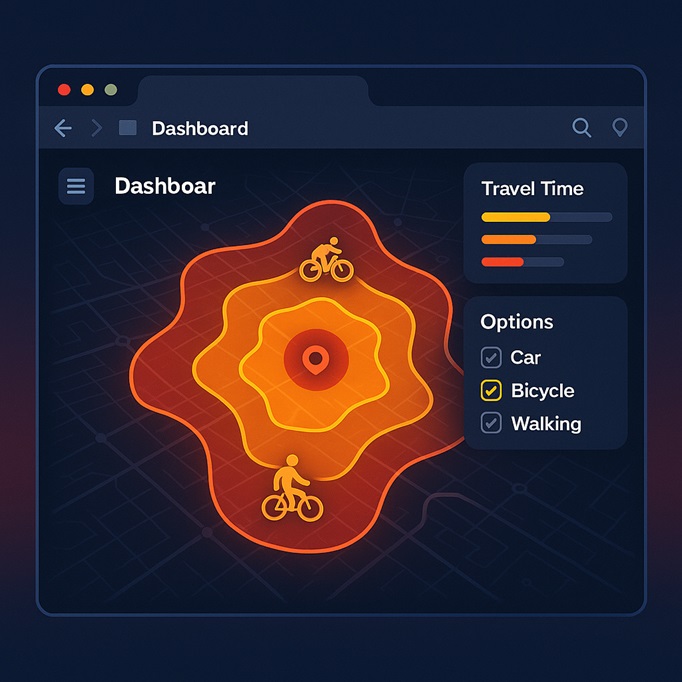
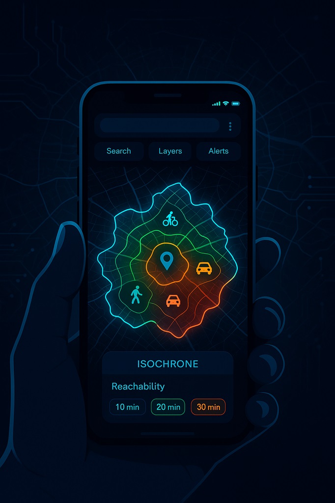
📌 What is an Isochrone and Why Does It Matter?
An isochrone represents the area reachable from a given point within a specific time threshold, considering road types, real speeds, and transport modes. It's a powerful tool for: 🚑 Planning emergency service coverage 🛒 Analyzing access to commercial zones and stores 🚌 Evaluating public transport connectivity 🌍 Studying urban and suburban mobility 🏥 Locating new facilities based on real-world reachability
🧱 Traditional Limitations: Desktop Tools or Slow APIs
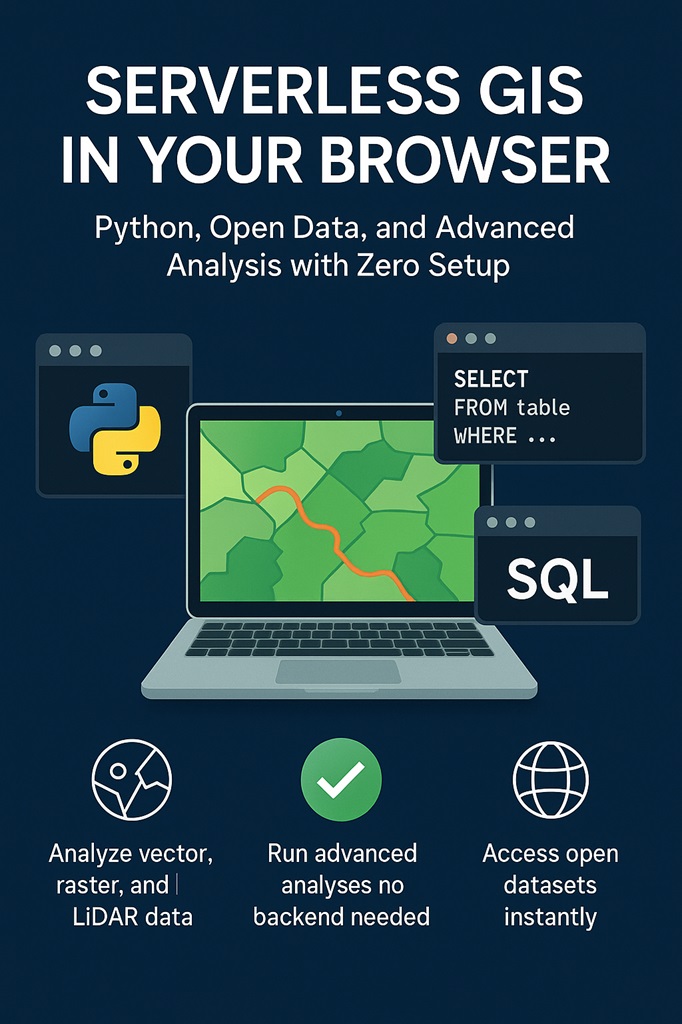
Until now, generating isochrones required: GIS desktop software (ArcGIS, QGIS, etc.) Instead of isolated usage of external APIs (OpenRouteService, Mapbox), often with: ✅limited speed ✅data privacy concerns ✅request quotas or cost ✅lack of flexibility Ipsilum unlocks their full potential by integrating these services directly into a unified geospatial environment. This means users can: ✅ Seamlessly combine isochrones with real-time data, ✅ Cross-analyze with custom datasets and rules, ✅ Embed results into dashboards, alerts, or decision flows — All within a browser, with no coding required. In short, Ipsilum transforms standalone geospatial tools into powerful, interactive solutions through integration, automation, and serverless execution. With Ipsilum, all of that changes.
⚡ The Ipsilum Breakthrough: Isochrones Instantly in the Browser
Imagine this: You open a web map Click on any point In less than a second, you get the reachable area in 5, 10, 15 or 20 minutes — by car, bike, foot, or transit No server calls. No software. No delay. This is powered by Ipsilum’s client-side execution model: Your browser runs optimized algorithms like Dijkstra or A* On top of pre-indexed road networks (GeoParquet) With real speeds, transport modes, and constraints.
🚀 Real-World Use Cases
🛻 Last-Mile Logistics Delivery companies simulate coverage areas and adjust logistics routes dynamically — directly on the map — adapting to road types, speeds, and traffic scenarios. 🧑⚕️ Public Health Access Municipalities evaluate real access to clinics or hospitals, prioritizing investments based on reachable populations rather than straight-line buffers. 🏪 Retail & Geomarketing Supermarket chains identify underserved areas not reachable within 15 minutes. Isochrone maps help optimize new store locations and marketing efforts. 🚨 Emergency Response Operators simulate real-time ambulance reach from any point. Isochrones help visualize urgent response windows and inform deployment decisions.
⚙️ How to Build an Isochrone System with Ipsilum
✅Load the Road Network Use your own GeoJSON / PMTiles / GeoParquet data — or leverage public data (e.g., Overture Maps). ✅Define Transport Rules Assign speeds and accessibility by mode (car, pedestrian, bike, transit...). Support for multimodal transfers included. ✅Build the Graph Ipsilum processes the network locally in your browser using efficient routing graph models. ✅One-Click Query Select a point, run the analysis instantly. Results appear as polygons — displayed on the map or exported in GeoJSON. ✅Combine with Other Layers Intersect isochrones with census, income, infrastructure or service layers for advanced spatial analysis — all in-browser.
🧩 Why Ipsilum? — Compared to Traditional GIS or API Tools
Feature Ipsilum (Modern GIS) Traditional GIS/API tools Installation None – 100% browser-based Requires desktop or backend Processing In-browser (client-side) Server-dependent Speed Instant (<1s) Slower, queued or limited Privacy / Data Control Local / self-hosted External APIs may leak data Flexibility Full: custom data, modes, rules Limited or closed configurations Integration Seamless with other Ipsilum modules Often fragmented or external
🧪 Want to Try It?
👉 Try our public demo: Isochrone Viewer Just click on any point on the map and see the results instantly.
✨ Final Thoughts
Isochrones are just one example of what’s possible with Ipsilum. We’re building the Modern GIS stack from the ground up — serverless, scalable, client-first. With Ipsilum, you don’t need: Local software Server infrastructure Complicated backend pipelines You only need: 🧠 your idea 🖱️ a browser 🗺️ and the power of Ipsilum.